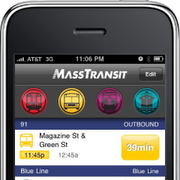
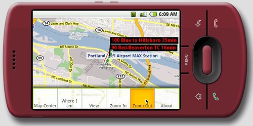
 Some 113 transit agencies provide open data that developers can use to create mobile applications.
This week, a report on Transparent Metro Data Sets was announced, which included a handy chart with side-by-side comparisons of data types for several transit agencies, relating to both bus and rail.
Numerous governmental institutions, including transit agencies, have jumped on the bandwagon to open up their data collections to the public so that information can be repurposed for the greater good.

City-Go-Round helps you find hundreds of useful transit applications around the country. They encourage public transit agencies to open their data to software developers. While many agencies now provide open data, many others do not.

To qualify as having open data, an agency must:
- Publish their schedule data as a GTFS feed. Google publishes instructions on how to create GTFS feeds.
- Provide an official URL where your feed can be downloaded.
- Send email to transit-developers@googlegroups.com with the URL of your feed. Note: this is a public mailing list.
Traffic 2.0 is an attempt to rethink transportation information.
Metroplan is an e-ink enabled system map, powered by an embedded array of solar cells. Metropass is an rfid transit card. Metropoint provides information about bus arrivals readable from up to 150 feet.

Juniper Research, in a study published today, says the combined revenues from pay apps, value-added services, subscriptions and advertising is expected to rise from just under $10 billion in 2009 to $32 billion in 2015.
Related Dailywireless location-based stories and transit connectivity stories include WiFi on Trains Conference, SF Bay Unwired, Smart Card for Toronto Transit, Transit TV in L.A., How to Create Transit Applications, Flickr Bike, Bikes and BART Get Mapped, Traffic Cameras Get Smart, Road Radar for Traffic Flow, Google Earth Gets “Live” Overlay, Cell Bazaar, iPad Street View, 360 Degree Haiti Video, Microsoft’s Streetside: Indoors via Stills & Video, 3D Mapping, Google Streetview on Cell Phones and Live Map Integrates Photosynth 3D Tours.
"
Tidak ada komentar:
Posting Komentar